
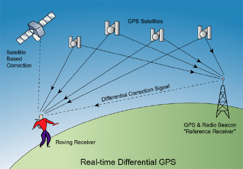
The first satellite navigation system, Transit, used by the United States Navy, was first successfully tested in 1960. It used a constellation of five satellites and could provide a navigational fix approximately once per hour. In 1967, the U.S. Navy developed the Timation satellite that proved the ability to place accurate clocks in space, a technology required by GPS. In the 1970s, the ground-based Omega Navigation System, based on phase comparison of signal transmission from pairs of stations, became the first worldwide radio navigation system. Limitations of these systems drove the need for a more universal navigation solution with greater accuracy. In 1996, recognizing the importance of GPS to civilian users as well as military users, U.S. President Bill Clinton issued a policy directive 25 declaring GPS to be a dual-use system and establishing an Interagency GPS Executive Board to manage it as a national asset. In 1998, United States Vice President Al Gore announced plans to upgrade GPS with two new civilian signals for enhanced user accuracy and reliability, particularly with respect to aviation safety and in 2000 the United States Congress authorized the effort, referring to it as GPS III.
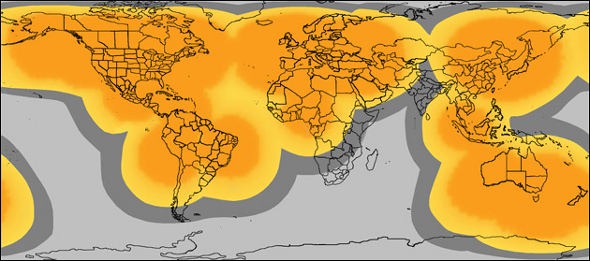
Today we can take GPS for granted safe in the knowledge that we usually know where we are, mobile phones can connect us to any phone network. Despite phone companies eagerness to mention full coverage in areas within built up areas of towns and cities, there are still places of little to no phone signal. Fortunately there is a device that utilizes the spot satellites round the world to communicate, rather then using mobile phone networks. Though paying a yearly subscription, you are safe with the knowledge that you can send messages or track your location or even send for help in the remotest areas of the world providing it is within the orange areas of the map above.
Another GPS device such as the Pocket finder is a small round object which can be given to your pets or your children for round the clock tracking. Along with software for your computer you can track, create geo fences and even determine the speed limit for any teenager. Most modern day uses for GPS seems to involve a social element, like geo tagging pictures or finding treasure. Now with devices getting smaller, it is possible to track your pets and children like a CIA operative and enforce some control. Spot satellites can provide coverage over most land masses, though at sea distress radio beacons, also known as emergency beacons, ELT or EPIRB, are tracking transmitters which aid in the detection and location of boats, aircraft, and people in distress. The average person with a phone should be relatively safe with todays technology. Allowing the rise of GPS function to go beyond emergency distress calls and communication to a social element. The future of GPS may well be in tracking everyones where a bouts, it certainly stating to appear in phone apps for dating and social networking.
No comments:
Post a Comment